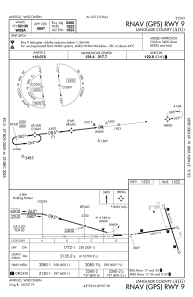
IAC chart of KAIG
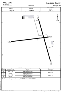
 ADC chart of KAIG
 Satellite view of KAIG
ADC chart of KAIG
Satellite view of KAIG
Sorry, we have no imagery here.
Sorry, we have no imagery here.
Sorry, we have no imagery here.
Sorry, we have no imagery here.
Sorry, we have no imagery here.
Sorry, we have no imagery here.


KAIG - Langlade County
Located in Antigo, United States
ICAO - AIG, IATA -
Data provided by AirmateGeneral information
Coordinates: N45°9'14" W89°6'38"
Elevation is 1523 feet MSL.
Magnetic variation is -02° East View others Airports in Wisconsin
Operational data
Special qualification required
Current time UTC:
Current local time:
Weather
METAR: KAIG 230215Z AUTO 36006KT 10SM SCT090 06/01 A3005 RMK AO2 T00560005
Communications frequencies: [VIEW]
Runways:
| RWY identifier | QFU | Length (ft) | Width (ft) | Surface | LDA (ft) |
| 09 | 83° | 3400 | 75 | ASPH | |
| 27 | 263° | 3400 | 75 | ASPH | |
| 17 | 164° | 4010 | 75 | ASPH | |
| 35 | 344° | 4010 | 75 | ASPH |
Airport contact information
Address: Antigo United States
Satellite view of KAIG
Sorry, we have no imagery here.
Sorry, we have no imagery here.
Sorry, we have no imagery here.
Sorry, we have no imagery here.
Sorry, we have no imagery here.
Sorry, we have no imagery here.