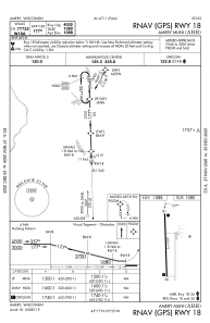
IAC chart of KAHH
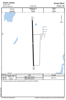
 ADC chart of KAHH
 Satellite view of KAHH
ADC chart of KAHH
Satellite view of KAHH
Sorry, we have no imagery here.
Sorry, we have no imagery here.
Sorry, we have no imagery here.
Sorry, we have no imagery here.
Sorry, we have no imagery here.
Sorry, we have no imagery here.


KAHH - Amery Muni
Located in Amery, United States
ICAO - AHH, IATA - AHH
Data provided by AirmateGeneral information
Coordinates: N45°16'52" W92°22'31"
Elevation is 1087 feet MSL.
Magnetic variation is 01° East View others Airports in Wisconsin
Operational data
Special qualification required
Current time UTC:
Current local time:
Weather at : KRNH - New Richmond Rgnl ( 20 km )
METAR: KRNH 230450Z AUTO 06005KT 10SM CLR 10/02 A3010 RMK AO2 T00990017
TAF: KRNH 222320Z 2300/2324 30007KT P6SM SCT070 FM230200 VRB03KT P6SM SKC FM230900 05005KT P6SM SKC FM231800 02007KT P6SM BKN080
Communications frequencies: [VIEW]
Runways:
| RWY identifier | QFU | Length (ft) | Width (ft) | Surface | LDA (ft) |
| 18 | 178° | 4000 | 75 | ASPH | |
| 36 | 358° | 4000 | 75 | ASPH |
Airport contact information
Address: Amery United States
Satellite view of KAHH
Sorry, we have no imagery here.
Sorry, we have no imagery here.
Sorry, we have no imagery here.
Sorry, we have no imagery here.
Sorry, we have no imagery here.
Sorry, we have no imagery here.