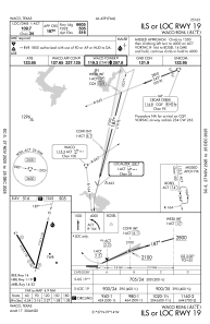
IAC chart of KACT
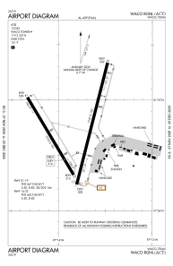
 ADC chart of KACT
 Satellite view of KACT
ADC chart of KACT
Satellite view of KACT
Sorry, we have no imagery here.
Sorry, we have no imagery here.
Sorry, we have no imagery here.
Sorry, we have no imagery here.
Sorry, we have no imagery here.


KACT - Waco Rgnl
Located in Waco, United States
ICAO - ACT, IATA - ACT
Data provided by AirmateGeneral information
Coordinates: N31°36'44" W97°13'49"
Elevation is 516 feet MSL.
Magnetic variation is 07° East View others Airports in Texas
Operational data
Special qualification required
Current time UTC:
Current local time:
Weather
METAR: KACT 020251Z 16015KT 10SM -RA CLR 23/20 A2955 RMK AO2 PK WND 15028/0209 SLP001 P0000 60000 T02330200 53011
TAF: KACT 020253Z 0203/0224 17018G28KT P6SM BKN035 FM020400 17015G25KT P6SM BKN015 FM021700 20010KT P6SM SCT025 FM022300 VRB05KT P6SM BKN050
Communications frequencies: [VIEW]
Runways:
| RWY identifier | QFU | Length (ft) | Width (ft) | Surface | LDA (ft) |
| 01 | 14° | 7107 | 150 | ASPH | 7005 |
| 19 | 194° | 7107 | 150 | ASPH | 6605 |
| 14 | 149° | 5103 | 150 | ASPH | 5103 |
| 32 | 329° | 5103 | 150 | ASPH | 5103 |
Airport contact information
Address: Waco United States
Other aviation service providers
Flight schools

Satellite view of KACT
Sorry, we have no imagery here.
Sorry, we have no imagery here.
Sorry, we have no imagery here.
Sorry, we have no imagery here.
Sorry, we have no imagery here.