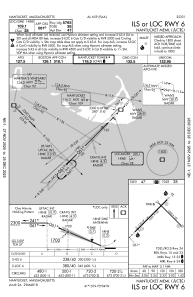
IAC chart of KACK
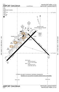
 ADC chart of KACK
 Satellite view of KACK
ADC chart of KACK
Satellite view of KACK
Sorry, we have no imagery here.
Sorry, we have no imagery here.
Sorry, we have no imagery here.
Sorry, we have no imagery here.
Sorry, we have no imagery here.
Sorry, we have no imagery here.


KACK - Nantucket Meml
Located in Nantucket, United States
ICAO - ACK, IATA - ACK
Data provided by AirmateGeneral information
Coordinates: N41°15'12" W70°3'38"
Elevation is 47 feet MSL.
Magnetic variation is -16° East View others Airports in Massachusetts
Operational data
Special qualification required
Current time UTC:
Current local time:
Weather
METAR: KACK 011353Z 33018G25KT 7SM BKN019 OVC035 08/06 A2971 RMK AO2 RAE1254 PRESRR SLP062 P0001 T00780056 $
TAF: KACK 011417Z 0114/0212 33018G25KT P6SM BKN019 OVC035 FM011500 34018G28KT P6SM BKN040 FM011800 35017G25KT P6SM SCT250 FM012300 35011KT P6SM FEW250 AMD NOT SKED
Communications frequencies: [VIEW]
Runways:
| RWY identifier | QFU | Length (ft) | Width (ft) | Surface | LDA (ft) |
| 06 | 45° | 6303 | 150 | ASPH | 5765 |
| 24 | 225° | 6303 | 150 | ASPH | 6303 |
| 15 | 135° | 4500 | 100 | ASPH | 4500 |
| 33 | 315° | 4500 | 100 | ASPH | 4500 |
Airport contact information
Address: Nantucket United States
Satellite view of KACK
Sorry, we have no imagery here.
Sorry, we have no imagery here.
Sorry, we have no imagery here.
Sorry, we have no imagery here.
Sorry, we have no imagery here.
Sorry, we have no imagery here.