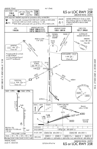
IAC chart of KABI
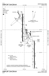
 ADC chart of KABI
 Satellite view of KABI
ADC chart of KABI
Satellite view of KABI
Sorry, we have no imagery here.
Sorry, we have no imagery here.
Sorry, we have no imagery here.
Sorry, we have no imagery here.
Sorry, we have no imagery here.
Sorry, we have no imagery here.


KABI - Abilene Rgnl
Located in Abilene, United States
ICAO - ABI, IATA - ABI
Data provided by AirmateGeneral information
Coordinates: N32°24'41" W99°40'55"
Elevation is 1790 feet MSL.
Magnetic variation is 05° East View others Airports in Texas
Operational data
Special qualification required
Current time UTC:
Current local time:
Weather
METAR: KABI 020052Z 20011KT 10SM CLR 31/08 A2943 RMK AO2 SLP939 T03110078
TAF: KABI 012322Z 0200/0224 19018G26KT P6SM BKN100 FM020800 24018G26KT P6SM BKN250 FM021200 31011KT P6SM SCT250 FM021700 29010G18KT P6SM SKC
Communications frequencies: [VIEW]
Runways:
| RWY identifier | QFU | Length (ft) | Width (ft) | Surface | LDA (ft) |
| 17L | 180° | 7198 | 150 | ASPH | 7198 |
| 35R | 360° | 7198 | 150 | ASPH | 7198 |
| 17R | 180° | 7208 | 150 | ASPH | 7202 |
| 35L | 360° | 7208 | 150 | ASPH | 7202 |
Airport contact information
Address: Abilene United States
Other aviation service providers
Flight schools

Satellite view of KABI
Sorry, we have no imagery here.
Sorry, we have no imagery here.
Sorry, we have no imagery here.
Sorry, we have no imagery here.
Sorry, we have no imagery here.
Sorry, we have no imagery here.