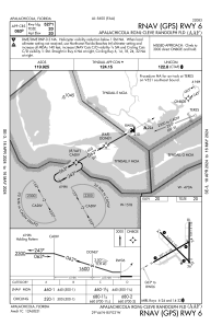
IAC chart of KAAF
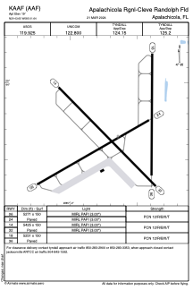
 ADC chart of KAAF
 Satellite view of KAAF
ADC chart of KAAF
Satellite view of KAAF
Sorry, we have no imagery here.
Sorry, we have no imagery here.
Sorry, we have no imagery here.
Sorry, we have no imagery here.
Sorry, we have no imagery here.
Sorry, we have no imagery here.


KAAF - Apalachicola Rgnl-Cleve Randolph Fld
Located in Apalachicola, United States
ICAO - AAF, IATA - AAF
Data provided by AirmateGeneral information
Coordinates: N29°43'39" W85°1'39"
Elevation is 19 feet MSL.
Magnetic variation is -03° East View others Airports in Florida
Operational data
Special qualification required
Current time UTC:
Current local time:
Weather
METAR: KAAF 051153Z AUTO 14008G18KT 10SM CLR 23/21 A3013 RMK AO2 SLP203 T02280211 10239 20228 53010 $
Communications frequencies: [VIEW]
Runways:
| RWY identifier | QFU | Length (ft) | Width (ft) | Surface | LDA (ft) |
| 06 | 60° | 5271 | 150 | CONC | |
| 24 | 240° | 5271 | 150 | CONC | |
| 14 | 135° | 5425 | 150 | CONC | |
| 32 | 315° | 5425 | 150 | CONC | |
| 18 | 180° | 5251 | 150 | CONC | |
| 36 | 0° | 5251 | 150 | CONC |
Airport contact information
Address: Apalachicola United States
Satellite view of KAAF
Sorry, we have no imagery here.
Sorry, we have no imagery here.
Sorry, we have no imagery here.
Sorry, we have no imagery here.
Sorry, we have no imagery here.
Sorry, we have no imagery here.