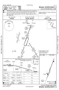
IAC chart of K89
 ADC chart of K89
 Satellite view of K89
ADC chart of K89
Satellite view of K89
Sorry, we have no imagery here.
Sorry, we have no imagery here.
Sorry, we have no imagery here.
Sorry, we have no imagery here.
Sorry, we have no imagery here.
Sorry, we have no imagery here.


K89 - Macon-Fower Meml
Located in Macon, United States
ICAO - K89, IATA -
Data provided by AirmateGeneral information
Coordinates: N39°43'47" W92°27'24"
Elevation is 878 feet MSL.
Magnetic variation is 02° East View others Airports in Missouri
Operational data
Special qualification required
Current time UTC:
Current local time:
Weather at : KMBY - Omar N Bradley ( 30 km )
METAR: KMBY 051115Z AUTO 35006KT 10SM CLR 05/02 A3013 RMK AO2
Communications frequencies: [VIEW]
Runways:
| RWY identifier | QFU | Length (ft) | Width (ft) | Surface | LDA (ft) |
| 02 | 20° | 4150 | 75 | CONC | |
| 20 | 200° | 4150 | 75 | CONC |
Airport contact information
Address: Macon United States
Satellite view of K89
Sorry, we have no imagery here.
Sorry, we have no imagery here.
Sorry, we have no imagery here.
Sorry, we have no imagery here.
Sorry, we have no imagery here.
Sorry, we have no imagery here.