ADC chart of K75
 Satellite view of K75
Satellite view of K75
Sorry, we have no imagery here.
Sorry, we have no imagery here.
Sorry, we have no imagery here.
Sorry, we have no imagery here.
Sorry, we have no imagery here.


K75 - Osborne Muni
Located in Osborne, United States
ICAO - K75, IATA -
Data provided by AirmateGeneral information
Coordinates: N39°25'60" W98°40'48"
Elevation is 1547 feet MSL.
Magnetic variation is 08° East View others Airports in Kansas
Operational data
Special qualification required
Current time UTC:
Current local time:
Weather at : KRSL - Russell Muni ( 63 km )
METAR: KRSL 120353Z AUTO 16014KT 10SM CLR 13/02 A3006 RMK AO2 SLP177 T01330017
TAF: KRSL 112322Z 1200/1224 16013KT P6SM SKC FM120800 17015G23KT P6SM SKC WS015/21050KT FM121500 18023G31KT P6SM SKC
Communications frequencies: [VIEW]
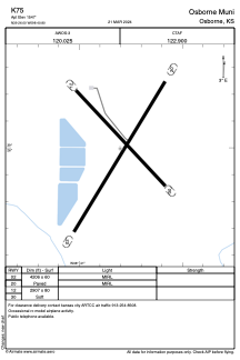
Runways:
| RWY identifier | QFU | Length (ft) | Width (ft) | Surface | LDA (ft) |
| 02 | 0° | 4206 | 60 | ASPH | |
| 20 | 0° | 4206 | 60 | ASPH | |
| 12 | 0° | 2907 | 80 | GRASS | |
| 30 | 0° | 2907 | 80 | GRASS |
Airport contact information
Address: Osborne United States
Satellite view of K75
Sorry, we have no imagery here.
Sorry, we have no imagery here.
Sorry, we have no imagery here.
Sorry, we have no imagery here.
Sorry, we have no imagery here.