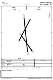
ADC chart of K51
 Satellite view of K51
Satellite view of K51
Sorry, we have no imagery here.
Sorry, we have no imagery here.
Sorry, we have no imagery here.
Sorry, we have no imagery here.
Sorry, we have no imagery here.


K51 - Medicine Lodge
Located in Medicine Lodge, United States
ICAO - K51, IATA -
Data provided by AirmateGeneral information
Coordinates: N37°15'55" W98°32'52"
Elevation is 1549 feet MSL.
Magnetic variation is 07° East View others Airports in Kansas
Operational data
Special qualification required
Current time UTC:
Current local time:
Weather at : KPTT - Pratt Rgnl ( 52 km )
METAR: KPTT 112355Z AUTO 16010KT 10SM CLR 22/M02 A3014 RMK AO2 T02221019 10242 20207
Communications frequencies: [VIEW]
Runways:
| RWY identifier | QFU | Length (ft) | Width (ft) | Surface | LDA (ft) |
| 16 | 174° | 3200 | 42 | ASPH | |
| 34 | 354° | 3200 | 42 | ASPH |
Airport contact information
Address: Medicine Lodge United States
Satellite view of K51
Sorry, we have no imagery here.
Sorry, we have no imagery here.
Sorry, we have no imagery here.
Sorry, we have no imagery here.
Sorry, we have no imagery here.