ADC chart of IA83
 Satellite view of IA83
Satellite view of IA83
Sorry, we have no imagery here.
Sorry, we have no imagery here.
Sorry, we have no imagery here.
Sorry, we have no imagery here.
Sorry, we have no imagery here.
Sorry, we have no imagery here.


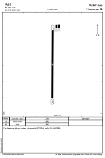
IA83 - Kohlhaas
Located in Livermore, United States
ICAO - IA83, IATA -
Data provided by AirmateGeneral information
Coordinates: N42°57'18" W94°10'3"
Elevation is 1155 feet MSL.
Magnetic variation is 04° East View others Airports in Iowa
Operational data
Special qualification required
Current time UTC:
Current local time:
Weather at : KAXA - Algona Muni ( 16 km )
METAR: KAXA 022315Z AUTO 26022G30KT 10SM OVC016 05/03 A2939 RMK A01
Communications frequencies: [VIEW]
Runways:
| RWY identifier | QFU | Length (ft) | Width (ft) | Surface | LDA (ft) |
| 17 | 180° | 2550 | 80 | GRASS | |
| 35 | 360° | 2550 | 80 | GRASS |
Airport contact information
Address: Livermore United States
Satellite view of IA83
Sorry, we have no imagery here.
Sorry, we have no imagery here.
Sorry, we have no imagery here.
Sorry, we have no imagery here.
Sorry, we have no imagery here.
Sorry, we have no imagery here.