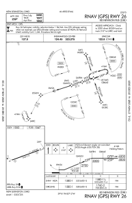
IAC chart of I86
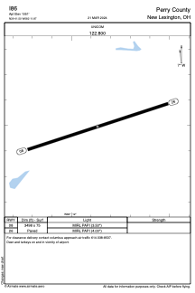
 ADC chart of I86
 Satellite view of I86
ADC chart of I86
Satellite view of I86
Sorry, we have no imagery here.
Sorry, we have no imagery here.
Sorry, we have no imagery here.
Sorry, we have no imagery here.
Sorry, we have no imagery here.
Sorry, we have no imagery here.


I86 - Ed Newlon Fld
Located in New Lexington, United States
ICAO - I86, IATA -
Data provided by AirmateGeneral information
Coordinates: N39°41'30" W82°11'52"
Elevation is 1051 feet MSL.
Magnetic variation is -07° East View others Airports in Ohio
Operational data
Special qualification required
Current time UTC:
Current local time:
Weather at : KZZV - Zanesville Muni ( 38 km )
METAR: KZZV 200453Z AUTO 16004KT 10SM BKN007 BKN021 OVC026 23/22 A2993 RMK AO2 CIG 004V012 SLP127 T02330222 402890194
TAF: KZZV 200417Z 2004/2024 24005KT P6SM VCSH OVC045 FM200600 24005KT P6SM VCSH BKN025 TEMPO 2008/2012 BKN015 FM201600 28008KT P6SM SCT040 BKN200 PROB30 2021/2024 5SM -TSRA BKN050CB
Communications frequencies: [VIEW]
Runways:
| RWY identifier | QFU | Length (ft) | Width (ft) | Surface | LDA (ft) |
| 08 | 72° | 3498 | 75 | ASPH | |
| 26 | 252° | 3498 | 75 | ASPH |
Airport contact information
Address: New Lexington United States
Satellite view of I86
Sorry, we have no imagery here.
Sorry, we have no imagery here.
Sorry, we have no imagery here.
Sorry, we have no imagery here.
Sorry, we have no imagery here.
Sorry, we have no imagery here.