ADC chart of I44
 Satellite view of I44
Satellite view of I44
Sorry, we have no imagery here.
Sorry, we have no imagery here.
Sorry, we have no imagery here.
Sorry, we have no imagery here.
Sorry, we have no imagery here.
Sorry, we have no imagery here.


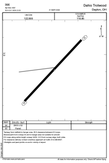
I44 - Dahio Trotwood
Located in Dayton, United States
ICAO - I44, IATA -
Data provided by AirmateGeneral information
Coordinates: N39°45'54" W84°20'35"
Elevation is 925 feet MSL.
Magnetic variation is -04° East View others Airports in Ohio
Operational data
Special qualification required
Current time UTC:
Current local time:
Weather at : KDAY - James M Cox Dayton Intl ( 19 km )
METAR: KDAY 080756Z 36010KT 10SM FEW030 M03/M09 A3001 RMK AO2 SLP169 T10281089 $
TAF: KDAY 080520Z 0806/0906 34014G22KT P6SM FEW050 FM081000 35010KT P6SM SKC FM081800 32009KT P6SM FEW050 FM082300 30008KT P6SM FEW050 FM090400 VRB03KT P6SM FEW100
Communications frequencies: [VIEW]
Runways:
| RWY identifier | QFU | Length (ft) | Width (ft) | Surface | LDA (ft) |
| 04 | 43° | 2900 | 52 | ASPH | |
| 22 | 223° | 2900 | 52 | ASPH |
Airport contact information
Address: Dayton United States
Satellite view of I44
Sorry, we have no imagery here.
Sorry, we have no imagery here.
Sorry, we have no imagery here.
Sorry, we have no imagery here.
Sorry, we have no imagery here.
Sorry, we have no imagery here.