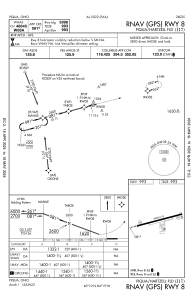
IAC chart of I17
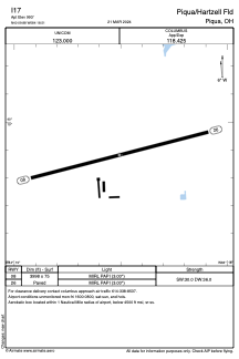
 ADC chart of I17
 Satellite view of I17
ADC chart of I17
Satellite view of I17
Sorry, we have no imagery here.
Sorry, we have no imagery here.
Sorry, we have no imagery here.
Sorry, we have no imagery here.
Sorry, we have no imagery here.


I17 - Piqua/Hartzell Fld
Located in Piqua, United States
ICAO - I17, IATA -
Data provided by AirmateGeneral information
Coordinates: N40°9'53" W84°18'30"
Elevation is 993 feet MSL.
Magnetic variation is -06° East View others Airports in Ohio
Operational data
Special qualification required
Current time UTC:
Current local time:
Weather at : KVES - Darke County ( 20 km )
METAR: KVES 081210Z AUTO 36010KT 10SM CLR M04/M09 A3012 RMK AO2
Communications frequencies: [VIEW]
Runways:
| RWY identifier | QFU | Length (ft) | Width (ft) | Surface | LDA (ft) |
| 08 | 76° | 3998 | 75 | ASPH | |
| 26 | 256° | 3998 | 75 | ASPH |
Airport contact information
Address: Piqua United States
Satellite view of I17
Sorry, we have no imagery here.
Sorry, we have no imagery here.
Sorry, we have no imagery here.
Sorry, we have no imagery here.
Sorry, we have no imagery here.