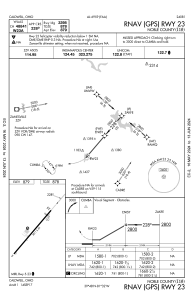
IAC chart of I10
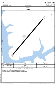
 ADC chart of I10
 Satellite view of I10
ADC chart of I10
Satellite view of I10
Sorry, we have no imagery here.
Sorry, we have no imagery here.
Sorry, we have no imagery here.
Sorry, we have no imagery here.
Sorry, we have no imagery here.
Sorry, we have no imagery here.


I10 - Noble County
Located in Caldwell, United States
ICAO - I10, IATA -
Data provided by AirmateGeneral information
Coordinates: N39°48'3" W81°32'11"
Elevation is 879 feet MSL.
Magnetic variation is -07° East View others Airports in Ohio
Operational data
Special qualification required
Current time UTC:
Current local time:
Weather at : KCDI - Cambridge Muni ( 20 km )
METAR: KCDI 081215Z AUTO 32007KT 300V360 10SM BKN035 M02/M08 A3004 RMK AO2 T10221082
Communications frequencies: [VIEW]
Runways:
| RWY identifier | QFU | Length (ft) | Width (ft) | Surface | LDA (ft) |
| 05 | 41° | 3811 | 65 | ASPH | |
| 23 | 221° | 3811 | 65 | ASPH |
Airport contact information
Address: Caldwell United States
Satellite view of I10
Sorry, we have no imagery here.
Sorry, we have no imagery here.
Sorry, we have no imagery here.
Sorry, we have no imagery here.
Sorry, we have no imagery here.
Sorry, we have no imagery here.