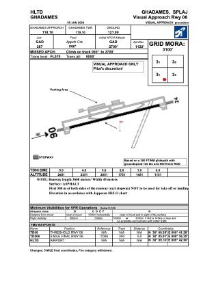
VAC chart of HLTD
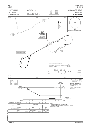
 IAC chart of HLTD
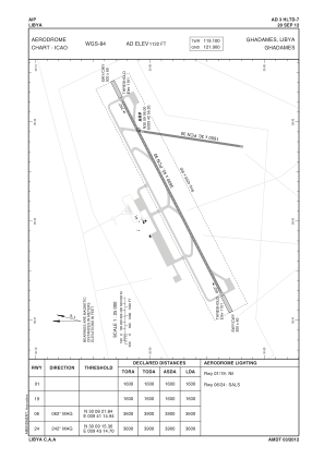
 ADC chart of HLTD
 Satellite view of HLTD
IAC chart of HLTDADC chart of HLTD
Satellite view of HLTD
Sorry, we have no imagery here.
Sorry, we have no imagery here.
Sorry, we have no imagery here.
Sorry, we have no imagery here.
Sorry, we have no imagery here.
Sorry, we have no imagery here.


HLTD - Ghadames
Located in Ghadames, Libyan Arab Jamahiriya
ICAO - HLTD, IATA - LTD
Data provided by AirmateGeneral information
Coordinates: N30°9'6" E9°42'55"
Elevation is 1122 feet MSL.
Magnetic variation is 2° East View others Airports in Nalut District
Operational data
Special qualification required
Current time UTC:
Current local time:
Weather at : - ( 0 km )
METAR: PAMD 280326Z AUTO 12017KT 7SM -RA FEW018 BKN035 OVC047 07/04 A2960 RMK AO2 PK WND 12026/0318 RAB18 PNO $
Communications frequencies: [VIEW]
Runways:
| RWY identifier | QFU | Length (ft) | Width (ft) | Surface | LDA (ft) |
| 06 | 62° | 11808 | 131 | ASPH | |
| 24 | 242° | 11808 | 131 | ASPH |
Airport contact information
Address: Ghadames Libyan Arab Jamahiriya
Satellite view of HLTD
Sorry, we have no imagery here.
Sorry, we have no imagery here.
Sorry, we have no imagery here.
Sorry, we have no imagery here.
Sorry, we have no imagery here.
Sorry, we have no imagery here.