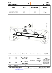
ADC chart of HLOKN
 Satellite view of HLOKN
Satellite view of HLOKN
Sorry, we have no imagery here.
Sorry, we have no imagery here.
Sorry, we have no imagery here.
Sorry, we have no imagery here.
Sorry, we have no imagery here.
Sorry, we have no imagery here.


HLOKN - Okba Ibn Nafa
Located in , Libyan Arab Jamahiriya
ICAO - , IATA -
Data provided by AirmateGeneral information
Coordinates: N32°28'19" E11°53'45"
Elevation is 253 feet MSL.
Operational data
Special qualification required
Current time UTC:
Current local time:
Weather at : - ( 0 km )
METAR: KMWT 051408Z AUTO VRB03KT 1 3/4SM +RA BR BKN009 BKN012 OVC018 13/11 A2983 RMK AO2 VIS 3/4V5 P0005 T01280106
Communications frequencies: [VIEW]
Runways:
| RWY identifier | QFU | Length (ft) | Width (ft) | Surface | LDA (ft) |
| 27 | 277° | 10481 | 143 | ASPH | |
| 09 | 97° | 10481 | 143 | ASPH |
Airport contact information
Address: Libyan Arab Jamahiriya
Satellite view of HLOKN
Sorry, we have no imagery here.
Sorry, we have no imagery here.
Sorry, we have no imagery here.
Sorry, we have no imagery here.
Sorry, we have no imagery here.
Sorry, we have no imagery here.