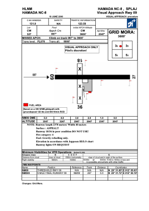
VAC chart of HLNM
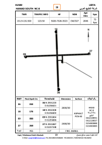
 ADC chart of HLNM
 Satellite view of HLNM
ADC chart of HLNM
Satellite view of HLNM
Sorry, we have no imagery here.
Sorry, we have no imagery here.
Sorry, we have no imagery here.
Sorry, we have no imagery here.
Sorry, we have no imagery here.
Sorry, we have no imagery here.


HLNM - Hamada Nc-8
Located in , Libyan Arab Jamahiriya
ICAO - , IATA -
Data provided by AirmateGeneral information
Coordinates: N29°31'52" E12°56'38"
Elevation is 2047 feet MSL.
Magnetic variation is 3° East View others Airports in Al Jabal al Gharbi District
Operational data
Special qualification required
Current time UTC:
Current local time:
Weather at : - ( 0 km )
METAR: KSHV 111756Z 32016G25KT 10SM CLR 27/02 A3020 RMK SLPNO
Communications frequencies: [VIEW]
Runways:
| RWY identifier | QFU | Length (ft) | Width (ft) | Surface | LDA (ft) |
| 09 | 89° | 7727 | 106 | ASPH | |
| 27 | 269° | 7727 | 106 | ASPH |
Airport contact information
Address: Libyan Arab Jamahiriya
Satellite view of HLNM
Sorry, we have no imagery here.
Sorry, we have no imagery here.
Sorry, we have no imagery here.
Sorry, we have no imagery here.
Sorry, we have no imagery here.
Sorry, we have no imagery here.