ADC chart of HLMAR
 Satellite view of HLMAR
Satellite view of HLMAR
Sorry, we have no imagery here.
Sorry, we have no imagery here.
Sorry, we have no imagery here.
Sorry, we have no imagery here.
Sorry, we have no imagery here.
Sorry, we have no imagery here.


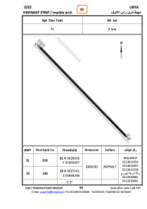
HLMAR - Marble Arch Highway Strip
Located in , Libyan Arab Jamahiriya
ICAO - , IATA -
Data provided by AirmateGeneral information
Coordinates: N30°26'36" E18°34'50"
Elevation is 71 feet MSL.
Operational data
Special qualification required
Current time UTC:
Current local time:
Weather at : - ( 0 km )
METAR: KGUL 050545Z AUTO 14013KT 2 1/2SM BR CLR A2981 RMK A01
Communications frequencies: [VIEW]
Runways:
| RWY identifier | QFU | Length (ft) | Width (ft) | Surface | LDA (ft) |
| 31 | 318° | 9140 | 89 | ASPH | |
| 13 | 138° | 9140 | 89 | ASPH |
Airport contact information
Address: Libyan Arab Jamahiriya
Satellite view of HLMAR
Sorry, we have no imagery here.
Sorry, we have no imagery here.
Sorry, we have no imagery here.
Sorry, we have no imagery here.
Sorry, we have no imagery here.
Sorry, we have no imagery here.