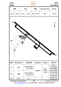
ADC chart of HLBC
 Satellite view of HLBC
Satellite view of HLBC
Sorry, we have no imagery here.
Sorry, we have no imagery here.
Sorry, we have no imagery here.
Sorry, we have no imagery here.
Sorry, we have no imagery here.
Sorry, we have no imagery here.


HLBC - Brack
Located in قيره, Libyan Arab Jamahiriya
ICAO - , IATA -
Data provided by AirmateGeneral information
Coordinates: N27°39'16" E14°15'46"
Elevation is 1477 feet MSL.
Magnetic variation is 3° East View others Airports in Wadi Al Shatii District
Operational data
Special qualification required
Current time UTC:
Current local time:
Weather at : - ( 0 km )
METAR: ZMUB 111700Z 00000MPS 9999 BKN250 M11/M17 Q1023 NOSIG RMK QFE659.6 59 NT
Communications frequencies: [VIEW]
Runways:
| RWY identifier | QFU | Length (ft) | Width (ft) | Surface | LDA (ft) |
| 31 | 310° | 11786 | 144 | ASPH | |
| 13 | 130° | 11786 | 144 | ASPH |
Airport contact information
Address: قيره Libyan Arab Jamahiriya
Satellite view of HLBC
Sorry, we have no imagery here.
Sorry, we have no imagery here.
Sorry, we have no imagery here.
Sorry, we have no imagery here.
Sorry, we have no imagery here.
Sorry, we have no imagery here.