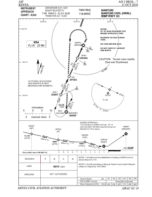
IAC chart of HKNL
 Satellite view of HKNL
Satellite view of HKNL
Sorry, we have no imagery here.
Sorry, we have no imagery here.
Sorry, we have no imagery here.
Sorry, we have no imagery here.
Sorry, we have no imagery here.
Sorry, we have no imagery here.


HKNL - Nanyuki Civil
Located in Gitinga Village, Kenya
ICAO - , IATA - NYK
Data provided by AirmateGeneral information
Coordinates: S0°3'44" E37°2'29"
Elevation is 6253 feet MSL.
Magnetic variation is 1° East View others Airports in Central Province
Operational data
Special qualification required
Current time UTC:
Current local time:
Communications frequencies: [VIEW]
Runways:
| RWY identifier | QFU | Length (ft) | Width (ft) | Surface | LDA (ft) |
| 03 | 29° | 4706 | 78 | DIRT | |
| 21 | 209° | 4706 | 78 | DIRT |
Airport contact information
Address: Gitinga Village Kenya
Satellite view of HKNL
Sorry, we have no imagery here.
Sorry, we have no imagery here.
Sorry, we have no imagery here.
Sorry, we have no imagery here.
Sorry, we have no imagery here.
Sorry, we have no imagery here.