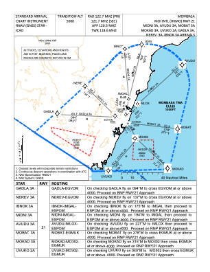
IAC chart of HKMO
 Satellite view of HKMO
Satellite view of HKMO
Sorry, we have no imagery here.
Sorry, we have no imagery here.
Sorry, we have no imagery here.
Sorry, we have no imagery here.
Sorry, we have no imagery here.
Sorry, we have no imagery here.


HKMO - Mombasa Moi Intl
Located in Mombasa, Kenya
ICAO - HKMO, IATA - MBA
Data provided by AirmateGeneral information
Coordinates: S4°1'35" E39°35'57"
Elevation is 200 feet MSL.
Magnetic variation is -1° East View others Airports in Coast Province
Operational data
Special qualification required
Current time UTC:
Current local time:
Weather
METAR: HKMO 120230Z 20008KT 9999 -SHRA BKN019 BKN080 26/24 Q1009 NOSIG
TAF: TAF HKMO 111700Z 1118/1224 16010KT 9999 SCT022 TEMPO 1121/1124 23005KT -SHRA SCT019 BKN080 BECMG 1209/1212 16010KT NSW SCT026 BECMG 1221/1224 22005KT SCT019
Communications frequencies: [VIEW]
Runways:
| RWY identifier | QFU | Length (ft) | Width (ft) | Surface | LDA (ft) |
| 03 | 29° | 6726 | 146 | ASPH | 10988 |
| 21 | 209° | 6726 | 146 | ASPH | 10988 |
| 15 | 150° | 4275 | 95 | ASPH | 4291 |
| 33 | 330° | 4275 | 95 | ASPH | 4291 |
Airport contact information
Address: Mombasa Kenya
Satellite view of HKMO
Sorry, we have no imagery here.
Sorry, we have no imagery here.
Sorry, we have no imagery here.
Sorry, we have no imagery here.
Sorry, we have no imagery here.
Sorry, we have no imagery here.