ADC chart of H70
 Satellite view of H70
Satellite view of H70
Sorry, we have no imagery here.
Sorry, we have no imagery here.
Sorry, we have no imagery here.
Sorry, we have no imagery here.
Sorry, we have no imagery here.
Sorry, we have no imagery here.


H70 - Stratford Fld
Located in Stratford, United States
ICAO - H70, IATA -
Data provided by AirmateGeneral information
Coordinates: N36°20'44" W102°2'57"
Elevation is 3668 feet MSL.
Magnetic variation is 09° East View others Airports in Texas
Operational data
Special qualification required
Current time UTC:
Current local time:
Weather at : KDUX - Moore County ( 54 km )
METAR: KDUX 021215Z AUTO 29012KT 10SM CLR 04/M10 A2958 RMK AO2 T00391097
Communications frequencies: [VIEW]
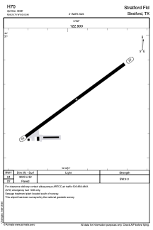
Runways:
| RWY identifier | QFU | Length (ft) | Width (ft) | Surface | LDA (ft) |
| 04 | 54° | 3023 | 32 | ASPH | |
| 22 | 234° | 3023 | 32 | ASPH |
Airport contact information
Address: Stratford United States
Satellite view of H70
Sorry, we have no imagery here.
Sorry, we have no imagery here.
Sorry, we have no imagery here.
Sorry, we have no imagery here.
Sorry, we have no imagery here.
Sorry, we have no imagery here.