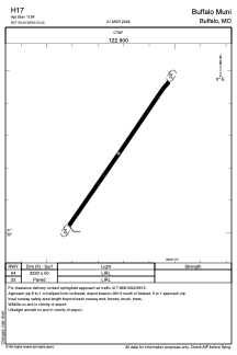
ADC chart of H17
 Satellite view of H17
Satellite view of H17
Sorry, we have no imagery here.
Sorry, we have no imagery here.
Sorry, we have no imagery here.
Sorry, we have no imagery here.
Sorry, we have no imagery here.
Sorry, we have no imagery here.


H17 - Buffalo Muni
Located in Buffalo, United States
ICAO - H17, IATA -
Data provided by AirmateGeneral information
Coordinates: N37°39'15" W93°5'13"
Elevation is 1154 feet MSL.
Magnetic variation is 04° East View others Airports in Missouri
Operational data
Special qualification required
Current time UTC:
Current local time:
Weather at : KLBO - Floyd W Jones Lebanon ( 38 km )
METAR: KLBO 050735Z AUTO 36011G16KT 5SM VCTSDZ OVC004 07/06 A3003 RMK AO2 LTG DSNT E AND SE
Communications frequencies: [VIEW]
Runways:
| RWY identifier | QFU | Length (ft) | Width (ft) | Surface | LDA (ft) |
| 04 | 0° | 3220 | 50 | ASPH | |
| 22 | 0° | 3220 | 50 | ASPH | |
| H1 | 0° | 0 | 0 | UNK |
Airport contact information
Address: Buffalo United States
Satellite view of H17
Sorry, we have no imagery here.
Sorry, we have no imagery here.
Sorry, we have no imagery here.
Sorry, we have no imagery here.
Sorry, we have no imagery here.
Sorry, we have no imagery here.