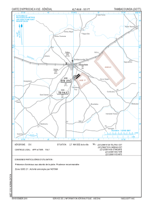
VAC chart of GOTT
 Satellite view of GOTT
Satellite view of GOTT
Sorry, we have no imagery here.
Sorry, we have no imagery here.
Sorry, we have no imagery here.
Sorry, we have no imagery here.
Sorry, we have no imagery here.
Sorry, we have no imagery here.


GOTT - Tambacounda
Located in Tambacounda, Senegal
ICAO - GOTT, IATA - TUD
Data provided by AirmateGeneral information
Coordinates: N13°43'58" W13°39'29"
Elevation is 161 feet MSL.
Magnetic variation is -5° East View others Airports in Tambacounda
Operational data
Special qualification required
Current time UTC:
Current local time:
Weather
METAR: GOTT 102100Z 22004KT CAVOK 37/19 Q1007
Communications frequencies: [VIEW]
Runways:
| RWY identifier | QFU | Length (ft) | Width (ft) | Surface | LDA (ft) |
| 06 | 49° | 6562 | 98 | CONC | 6562 |
| 24 | 229° | 6562 | 98 | CONC | 6562 |
Airport contact information
Address: Tambacounda Senegal
Satellite view of GOTT
Sorry, we have no imagery here.
Sorry, we have no imagery here.
Sorry, we have no imagery here.
Sorry, we have no imagery here.
Sorry, we have no imagery here.
Sorry, we have no imagery here.