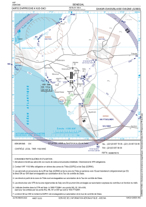
VAC chart of GOBD
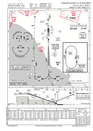
 IAC chart of GOBD
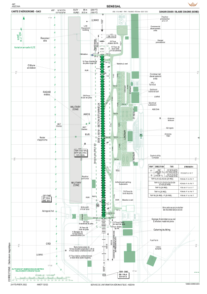
 ADC chart of GOBD
 Satellite view of GOBD
IAC chart of GOBDADC chart of GOBD
Satellite view of GOBD
Sorry, we have no imagery here.
Sorry, we have no imagery here.
Sorry, we have no imagery here.
Sorry, we have no imagery here.
Sorry, we have no imagery here.


GOBD - Aeroport Intl Blaise Diagne - Dakar - Diass
Located in Dakar, Senegal
ICAO - , IATA - DSS
Data provided by AirmateGeneral information
Coordinates: N14°40'15" W17°4'22"
Elevation is 290 feet MSL.
Magnetic variation is -6° East View others Airports in Dakar
Operational data
Special qualification required
Current time UTC:
Current local time:
Weather
METAR: GOBD 110730Z 36012KT 8000 BKN008 19/19 Q1011 NOSIG
TAF: TAF GOBD 110500Z 1106/1212 36012KT 8000 FEW012
Communications frequencies: [VIEW]
Runways:
| RWY identifier | QFU | Length (ft) | Width (ft) | Surface | LDA (ft) |
| 01 | 360° | 11483 | 197 | CONC | 11483 |
| 19 | 180° | 11483 | 197 | CONC | 11483 |
Airport contact information
Address: Dakar Senegal
Satellite view of GOBD
Sorry, we have no imagery here.
Sorry, we have no imagery here.
Sorry, we have no imagery here.
Sorry, we have no imagery here.
Sorry, we have no imagery here.