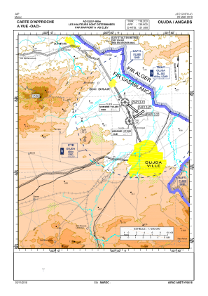
VAC chart of GMFO
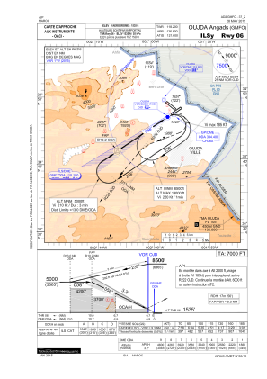
 IAC chart of GMFO
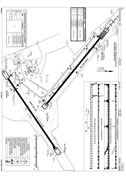
 ADC chart of GMFO
 Satellite view of GMFO
IAC chart of GMFOADC chart of GMFO
Satellite view of GMFO
Sorry, we have no imagery here.
Sorry, we have no imagery here.
Sorry, we have no imagery here.
Sorry, we have no imagery here.
Sorry, we have no imagery here.
Sorry, we have no imagery here.


GMFO - Oujda/Angads
Located in Oujda, Morocco
ICAO - GMFO, IATA - OUD
Data provided by AirmateGeneral information
Coordinates: N34°47'10" W1°55'32"
Elevation is 1535 feet MSL.
Magnetic variation is 1° East View others Airports in Oujda
Operational data
Special qualification required
Current time UTC:
Current local time:
Weather
METAR: GMFO 111100Z 20021KT 8000 -RA FEW030 SCT046 27/04 Q1013 NOSIG
TAF: TAF GMFO 111100Z 1112/1218 20016KT 8000 FEW030 SCT046 PROB30 TEMPO 1116/1122 19019G30KT SHRA FEW040CB
Communications frequencies: [VIEW]
Runways:
| RWY identifier | QFU | Length (ft) | Width (ft) | Surface | LDA (ft) |
| 06 | 58° | 9790 | 138 | ASPH | 9843 |
| 24 | 238° | 9790 | 138 | ASPH | 9843 |
| 13 | 131° | 9800 | 145 | ASPH | 9843 |
| 31 | 311° | 9800 | 145 | ASPH | 9843 |
Airport contact information
Address: Oujda Morocco
Satellite view of GMFO
Sorry, we have no imagery here.
Sorry, we have no imagery here.
Sorry, we have no imagery here.
Sorry, we have no imagery here.
Sorry, we have no imagery here.
Sorry, we have no imagery here.