VAC chart of GMAD
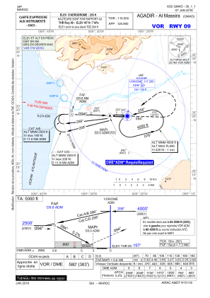
 IAC chart of GMAD
 ADC chart of GMAD
 Satellite view of GMAD
IAC chart of GMADADC chart of GMAD
Satellite view of GMAD
Sorry, we have no imagery here.
Sorry, we have no imagery here.
Sorry, we have no imagery here.
Sorry, we have no imagery here.
Sorry, we have no imagery here.
Sorry, we have no imagery here.


GMAD - Agadir/Al Massira
Located in Agadir, Morocco
ICAO - GMAD, IATA - AGA
Data provided by AirmateGeneral information
Coordinates: N30°19'21" W9°24'41"
Elevation is 252 feet MSL.
Magnetic variation is -2° East View others Airports in Agadir
Operational data
Special qualification required
Current time UTC:
Current local time:
Weather
METAR: GMAD 101030Z 06004KT CAVOK 23/13 Q1008 NOSIG
TAF: TAF GMAD 100500Z 1006/1112 06005KT 8000 NSC BECMG 1012/1014 28012KT BECMG 1018/1021 10005KT
Communications frequencies: [VIEW]
Runways:
| RWY identifier | QFU | Length (ft) | Width (ft) | Surface | LDA (ft) |
| 09 | 92° | 10440 | 146 | ASPH | 10499 |
| 27 | 272° | 10440 | 146 | ASPH | 10499 |
Airport contact information
Address: Agadir Morocco
Satellite view of GMAD
Sorry, we have no imagery here.
Sorry, we have no imagery here.
Sorry, we have no imagery here.
Sorry, we have no imagery here.
Sorry, we have no imagery here.
Sorry, we have no imagery here.