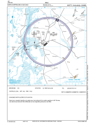
VAC chart of GAMB
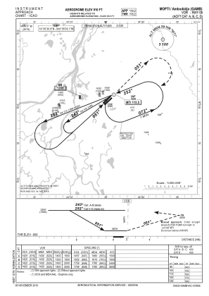
 IAC chart of GAMB
 Satellite view of GAMB
IAC chart of GAMB
Satellite view of GAMB
Sorry, we have no imagery here.
Sorry, we have no imagery here.
Sorry, we have no imagery here.
Sorry, we have no imagery here.
Sorry, we have no imagery here.
Sorry, we have no imagery here.


GAMB - Mopti/Ambodedjo
Located in Mopti, Mali
ICAO - GAMB, IATA - MZI
Data provided by AirmateGeneral information
Coordinates: N14°30'31" W4°5'3"
Elevation is 910 feet MSL.
View others Airports in Mopti
Operational data
Special qualification required
Current time UTC:
Current local time:
Weather
METAR: GAMB 250800Z 02008KT 4000 DU NSC 20/02 Q1017
Communications frequencies: [VIEW]
Runways:
| RWY identifier | QFU | Length (ft) | Width (ft) | Surface | LDA (ft) |
| 05 | 47° | 8333 | 98 | ASP | |
| 23 | 227° | 8333 | 98 | ASP |
Airport contact information
Address: Mopti Mali
Satellite view of GAMB
Sorry, we have no imagery here.
Sorry, we have no imagery here.
Sorry, we have no imagery here.
Sorry, we have no imagery here.
Sorry, we have no imagery here.
Sorry, we have no imagery here.