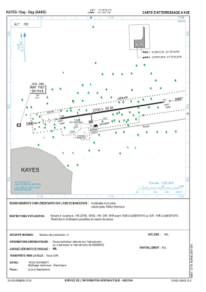
VAC chart of GAKD
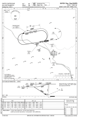
 IAC chart of GAKD
 Satellite view of GAKD

IAC chart of GAKD
Satellite view of GAKD
Sorry, we have no imagery here.
Sorry, we have no imagery here.
Sorry, we have no imagery here.
Sorry, we have no imagery here.
Sorry, we have no imagery here.
Sorry, we have no imagery here.


GAKD - Kayes Dag-Dag
Located in Kayes, Mali
ICAO - , IATA - KYS
Data provided by AirmateGeneral information
Coordinates: N14°28'54" W11°24'7"
Elevation is 164 feet MSL.
View others Airports in Kayes
Operational data
Special qualification required
Current time UTC:
Current local time:
Weather
METAR: GAKD 250000Z 03010KT 8000 NSC 27/M06 Q1016
Communications frequencies: [VIEW]
Runways:
| RWY identifier | QFU | Length (ft) | Width (ft) | Surface | LDA (ft) |
| 09 | 81° | 8858 | 148 | UNK | |
| 27 | 261° | 8858 | 148 | UNK |
Airport contact information
Address: Kayes Mali
Satellite view of GAKD
Sorry, we have no imagery here.
Sorry, we have no imagery here.
Sorry, we have no imagery here.
Sorry, we have no imagery here.
Sorry, we have no imagery here.
Sorry, we have no imagery here.