VAC chart of GAGO
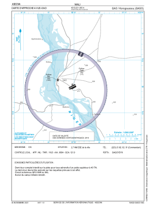 IAC chart of GAGO
 ADC chart of GAGO
 Satellite view of GAGO
IAC chart of GAGOADC chart of GAGO
Satellite view of GAGO
Sorry, we have no imagery here.
Sorry, we have no imagery here.
Sorry, we have no imagery here.
Sorry, we have no imagery here.
Sorry, we have no imagery here.
Sorry, we have no imagery here.


GAGO - Gao/Korogoussou
Located in Gao, Mali
ICAO - GAGO, IATA - GAQ
Data provided by AirmateGeneral information
Coordinates: N16°14'54" W0°0'21"
Elevation is 870 feet MSL.
View others Airports in Gao
Operational data
Special qualification required
Current time UTC:
Current local time:
Weather
TAF: TAF GAGO 250508Z 2506/2606 02010KT 6000 NSC TEMPO 2508/2514 04016G26KT 2500 BLDU
Communications frequencies: [VIEW]
Runways:
| RWY identifier | QFU | Length (ft) | Width (ft) | Surface | LDA (ft) |
| 06L | 63° | 8202 | 148 | UNK | |
| 24R | 243° | 8202 | 148 | UNK | |
| 06R | 63° | 5906 | 98 | UNK | |
| 24L | 243° | 5906 | 98 | UNK |
Airport contact information
Address: Gao Mali
Satellite view of GAGO
Sorry, we have no imagery here.
Sorry, we have no imagery here.
Sorry, we have no imagery here.
Sorry, we have no imagery here.
Sorry, we have no imagery here.
Sorry, we have no imagery here.