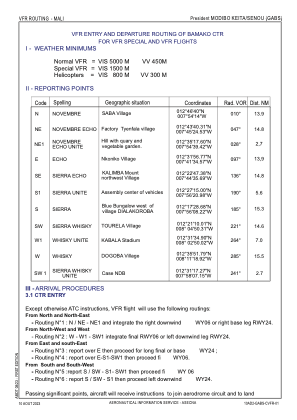
VAC chart of GABS
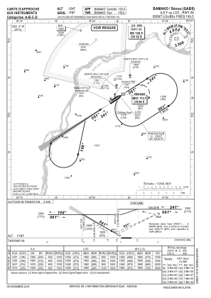
 IAC chart of GABS
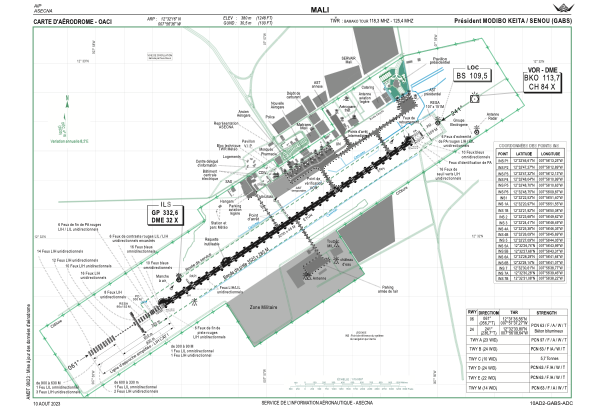
 ADC chart of GABS
 Satellite view of GABS

IAC chart of GABSADC chart of GABS
Satellite view of GABS
Sorry, we have no imagery here.
Sorry, we have no imagery here.
Sorry, we have no imagery here.
Sorry, we have no imagery here.
Sorry, we have no imagery here.
Sorry, we have no imagery here.


GABS - Aeroport International President Modibo Keita-Senou
Located in Bamako, Mali
ICAO - GABS, IATA - BKO
Data provided by AirmateGeneral information
Coordinates: N12°32'16" W7°56'35"
Elevation is 1247 feet MSL.
View others Airports in Koulikoro
Operational data
Special qualification required
Current time UTC:
Current local time:
Weather
METAR: GABS 250800Z 05018KT 6000 NSC 21/M02 Q1018 BECMG 4000 DU
TAF: TAF GABS 250506Z 2506/2612 04010KT 6000 NSC TEMPO 2508/2514 04016G26KT 4000 DRDU
Communications frequencies: [VIEW]
Runways:
| RWY identifier | QFU | Length (ft) | Width (ft) | Surface | LDA (ft) |
| 06 | 57° | 10499 | 148 | ASP | |
| 24 | 237° | 10499 | 148 | ASP |
Airport contact information
Address: Bamako Mali
Satellite view of GABS
Sorry, we have no imagery here.
Sorry, we have no imagery here.
Sorry, we have no imagery here.
Sorry, we have no imagery here.
Sorry, we have no imagery here.
Sorry, we have no imagery here.