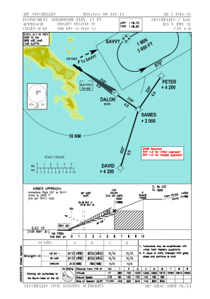
IAC chart of FSIA
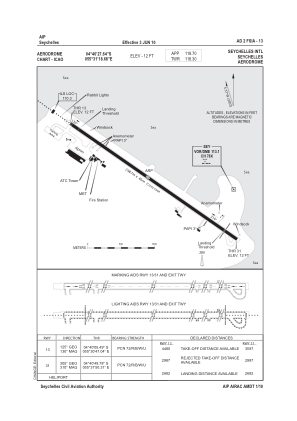
 ADC chart of FSIA
 Satellite view of FSIA
ADC chart of FSIA
Satellite view of FSIA
Sorry, we have no imagery here.
Sorry, we have no imagery here.
Sorry, we have no imagery here.
Sorry, we have no imagery here.
Sorry, we have no imagery here.
Sorry, we have no imagery here.


FSIA - Seychelles International
Located in Victoria, Seychelles
ICAO - FSIA, IATA - SEZ
Data provided by AirmateGeneral information
Coordinates: S4°40'28" E55°31'19"
Elevation is 12 feet MSL.
View others Airports in Pointe La Rue
Operational data
Special qualification required
Current time UTC:
Current local time:
Weather
METAR: FSIA 250800Z 36010KT 9999 SCT021 31/25 Q1012 NOSIG
TAF: TAF FSIA 250501Z 2506/2606 35007KT 9999 SCT022
Communications frequencies: [VIEW]
Runways:
| RWY identifier | QFU | Length (ft) | Width (ft) | Surface | LDA (ft) |
| 13 | 125° | 9800 | 151 | CON | |
| 31 | 305° | 9800 | 151 | CON |
Airport contact information
Address: Victoria Seychelles
Satellite view of FSIA
Sorry, we have no imagery here.
Sorry, we have no imagery here.
Sorry, we have no imagery here.
Sorry, we have no imagery here.
Sorry, we have no imagery here.
Sorry, we have no imagery here.