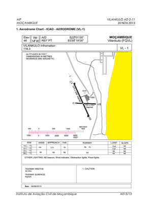
ADC chart of FQVL
 Satellite view of FQVL

Satellite view of FQVL
Sorry, we have no imagery here.
Sorry, we have no imagery here.
Sorry, we have no imagery here.
Sorry, we have no imagery here.
Sorry, we have no imagery here.
Sorry, we have no imagery here.


FQVL - Vilankulo / National
Located in Vilankulo, Mozambique
ICAO - FQVL, IATA - VNX
Data provided by AirmateGeneral information
Coordinates: S22°1'7" E35°18'47"
Elevation is 46 feet MSL.
View others Airports in Inhambane Province
Operational data
Special qualification required
Current time UTC:
Current local time:
Weather
METAR: FQVL 091300Z 12008KT 9999 FEW020 33/25 Q1009
TAF: TAF FQVL 090400Z 0906/1006 16012KT 9999 SCT020 TX33/0913Z TN25/1002Z BECMG 0910/0912 10010KT
Communications frequencies: [VIEW]
Runways:
| RWY identifier | QFU | Length (ft) | Width (ft) | Surface | LDA (ft) |
| 10 | 89° | 2461 | 75 | ASP | |
| 28 | 269° | 2461 | 75 | ASP | |
| 17 | 156° | 4823 | 98 | ASP | |
| 35 | 336° | 4823 | 98 | ASP |
Airport contact information
Address: Vilankulo Mozambique
Satellite view of FQVL
Sorry, we have no imagery here.
Sorry, we have no imagery here.
Sorry, we have no imagery here.
Sorry, we have no imagery here.
Sorry, we have no imagery here.
Sorry, we have no imagery here.