


FQPB - Pemba / National
Located in Pemba, Mozambique
ICAO - FQPB, IATA - POL
Data provided by AirmateGeneral information
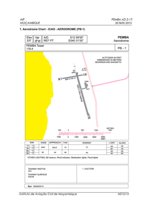
Coordinates: S12°59'12" E40°31'20"
Elevation is 331 feet MSL.
View others Airports in Cabo Delgado Province
Operational data
Special qualification required
Current time UTC:
Current local time:
Weather
METAR: FQPB 262100Z 20012KT 9999 FEW020 BKN100 24/24 Q1019
TAF: TAF FQPB 261000Z 2612/2712 17015G25KT 9999 SCT020 TX30/2613Z TN20/2702Z BECMG 2618/2620 16013KT
Communications frequencies: [VIEW]
Runways:
| RWY identifier | QFU | Length (ft) | Width (ft) | Surface | LDA (ft) |
| 08 | 78° | 2625 | 98 | ASP | |
| 26 | 258° | 2625 | 98 | ASP | |
| 17 | 161° | 5906 | 148 | ASP | |
| 35 | 341° | 5906 | 148 | ASP |
Airport contact information
Address: Pemba Mozambique