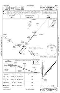
IAC chart of F98
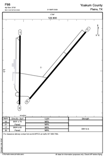
 ADC chart of F98
 Satellite view of F98
ADC chart of F98
Satellite view of F98
Sorry, we have no imagery here.
Sorry, we have no imagery here.
Sorry, we have no imagery here.
Sorry, we have no imagery here.
Sorry, we have no imagery here.
Sorry, we have no imagery here.


F98 - Yoakum County
Located in Plains, United States
ICAO - F98, IATA -
Data provided by AirmateGeneral information
Coordinates: N33°13'2" W102°49'48"
Elevation is 3705 feet MSL.
Magnetic variation is 07° East View others Airports in Texas
Operational data
Special qualification required
Current time UTC:
Current local time:
Weather at : KGNC - Gaines County ( 62 km )
METAR: KGNC 020435Z AUTO 22011KT 7SM BKN019 BKN025 22/M03 A2952 RMK AO2 T02191035
Communications frequencies: [VIEW]
Runways:
| RWY identifier | QFU | Length (ft) | Width (ft) | Surface | LDA (ft) |
| 03 | 40° | 5001 | 75 | ASPH | |
| 21 | 220° | 5001 | 75 | ASPH | |
| 17 | 180° | 3924 | 60 | ASPH | |
| 35 | 360° | 3924 | 60 | ASPH |
Airport contact information
Address: Plains United States
Satellite view of F98
Sorry, we have no imagery here.
Sorry, we have no imagery here.
Sorry, we have no imagery here.
Sorry, we have no imagery here.
Sorry, we have no imagery here.
Sorry, we have no imagery here.