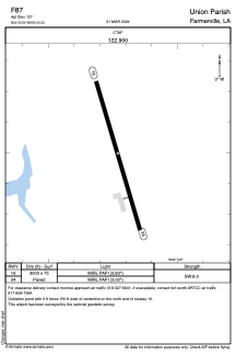
ADC chart of F87
 Satellite view of F87
Satellite view of F87
Sorry, we have no imagery here.
Sorry, we have no imagery here.
Sorry, we have no imagery here.
Sorry, we have no imagery here.
Sorry, we have no imagery here.
Sorry, we have no imagery here.


F87 - Union Parish
Located in Farmerville, United States
ICAO - F87, IATA -
Data provided by AirmateGeneral information
Coordinates: N32°43'29" W92°20'14"
Elevation is 121 feet MSL.
Magnetic variation is 05° East View others Airports in Louisiana
Operational data
Special qualification required
Current time UTC:
Current local time:
Weather at : KRSN - Ruston Rgnl ( 33 km )
METAR: KRSN 082155Z AUTO VRB05KT 10SM FEW080 22/03 A3008 RMK AO2 T02180026
Communications frequencies: [VIEW]
Runways:
| RWY identifier | QFU | Length (ft) | Width (ft) | Surface | LDA (ft) |
| 16 | 163° | 3003 | 75 | ASPH | |
| 34 | 343° | 3003 | 75 | ASPH |
Airport contact information
Address: Farmerville United States
Satellite view of F87
Sorry, we have no imagery here.
Sorry, we have no imagery here.
Sorry, we have no imagery here.
Sorry, we have no imagery here.
Sorry, we have no imagery here.
Sorry, we have no imagery here.