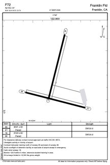
ADC chart of F72
 Satellite view of F72
Satellite view of F72
Sorry, we have no imagery here.
Sorry, we have no imagery here.
Sorry, we have no imagery here.
Sorry, we have no imagery here.
Sorry, we have no imagery here.
Sorry, we have no imagery here.


F72 - Franklin Fld
Located in Franklin, United States
ICAO - F72, IATA -
Data provided by AirmateGeneral information
Coordinates: N38°18'14" W121°25'46"
Elevation is 23 feet MSL.
Magnetic variation is 16° East View others Airports in California
Operational data
Special qualification required
Current time UTC:
Current local time:
Weather at : KSAC - Sacramento Exec ( 24 km )
METAR: KSAC 051353Z 32003KT 10SM CLR 07/05 A3026 RMK AO2 SLP245 T00670050
TAF: KSAC 051125Z 0512/0612 VRB04KT P6SM SCT250 FM060100 22005KT P6SM SCT250 FM060800 18005KT P6SM SKC
Communications frequencies: [VIEW]
Runways:
| RWY identifier | QFU | Length (ft) | Width (ft) | Surface | LDA (ft) |
| 09 | 104° | 3031 | 60 | ASPH | |
| 27 | 284° | 3031 | 60 | ASPH | |
| 18 | 194° | 3123 | 60 | ASPH | |
| 36 | 14° | 3123 | 60 | ASPH |
Airport contact information
Address: Franklin United States
Satellite view of F72
Sorry, we have no imagery here.
Sorry, we have no imagery here.
Sorry, we have no imagery here.
Sorry, we have no imagery here.
Sorry, we have no imagery here.
Sorry, we have no imagery here.