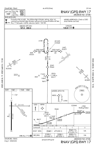
IAC chart of F56
 Satellite view of F56
Satellite view of F56
Sorry, we have no imagery here.
Sorry, we have no imagery here.
Sorry, we have no imagery here.
Sorry, we have no imagery here.
Sorry, we have no imagery here.


F56 - Arledge Fld
Located in Stamford, United States
ICAO - F56, IATA -
Data provided by AirmateGeneral information
Coordinates: N32°54'38" W99°44'3"
Elevation is 1561 feet MSL.
Magnetic variation is 06° East View others Airports in Texas
Operational data
Special qualification required
Current time UTC:
Current local time:
Weather at : KABI - Abilene Rgnl ( 56 km )
METAR: KABI 021352Z 30006KT 10SM BKN060 18/M01 A2965 RMK AO2 SLP016 T01831011
TAF: KABI 021337Z 0214/0312 32011G17KT P6SM SCT250 FM021700 29010G18KT P6SM SKC FM022200 14010G18KT P6SM SCT250 FM030600 06010KT P6SM BKN050 PROB30 0306/0312 4SM -TSRA BKN025CB
Communications frequencies: [VIEW]
Runways:
| RWY identifier | QFU | Length (ft) | Width (ft) | Surface | LDA (ft) |
| 08 | 91° | 2211 | 50 | GRASS | |
| 26 | 271° | 2211 | 50 | GRASS | |
| 13 | 136° | 1702 | 50 | OTHER | |
| 31 | 316° | 1702 | 50 | OTHER | |
| 17 | 180° | 3707 | 60 | ASPH | |
| 35 | 0° | 3707 | 60 | ASPH |
Airport contact information
Address: Stamford United States
Satellite view of F56
Sorry, we have no imagery here.
Sorry, we have no imagery here.
Sorry, we have no imagery here.
Sorry, we have no imagery here.
Sorry, we have no imagery here.