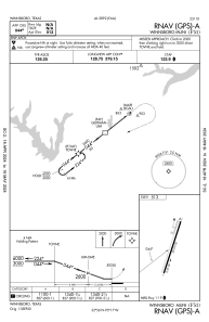
IAC chart of F51
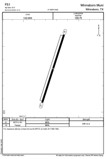
 ADC chart of F51
 Satellite view of F51
ADC chart of F51
Satellite view of F51
Sorry, we have no imagery here.
Sorry, we have no imagery here.
Sorry, we have no imagery here.
Sorry, we have no imagery here.
Sorry, we have no imagery here.
Sorry, we have no imagery here.


F51 - Winnsboro Muni
Located in Winnsboro, United States
ICAO - F51, IATA -
Data provided by AirmateGeneral information
Coordinates: N32°56'20" W95°16'44"
Elevation is 513 feet MSL.
Magnetic variation is 08° East View others Airports in Texas
Operational data
Special qualification required
Current time UTC:
Current local time:
Weather at : KJDD - Wood County/Collins Fld ( 30 km )
METAR: KJDD 021335Z AUTO 19011G19KT 140V210 8SM BKN023 OVC029 24/20 A2956 RMK AO2 CIG 021V026 T02400203 $
Communications frequencies: [VIEW]
Runways:
| RWY identifier | QFU | Length (ft) | Width (ft) | Surface | LDA (ft) |
| 01 | 18° | 3215 | 50 | ASPH | |
| 19 | 198° | 3215 | 50 | ASPH |
Airport contact information
Address: Winnsboro United States
Satellite view of F51
Sorry, we have no imagery here.
Sorry, we have no imagery here.
Sorry, we have no imagery here.
Sorry, we have no imagery here.
Sorry, we have no imagery here.
Sorry, we have no imagery here.