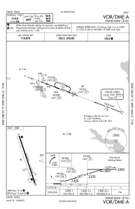
IAC chart of F41
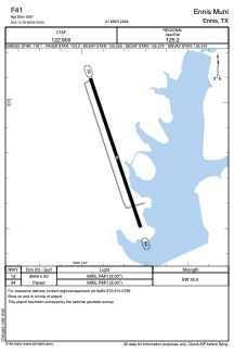
 ADC chart of F41
 Satellite view of F41
ADC chart of F41
Satellite view of F41
Sorry, we have no imagery here.
Sorry, we have no imagery here.
Sorry, we have no imagery here.
Sorry, we have no imagery here.
Sorry, we have no imagery here.
Sorry, we have no imagery here.


F41 - Ennis Muni
Located in Ennis, United States
ICAO - F41, IATA -
Data provided by AirmateGeneral information
Coordinates: N32°19'47" W96°39'50"
Elevation is 500 feet MSL.
Magnetic variation is 03° East View others Airports in Texas
Operational data
Special qualification required
Current time UTC:
Current local time:
Weather at : KJWY - Mid-Way Rgnl ( 27 km )
METAR: KJWY 021335Z AUTO 20012KT 7SM OVC017 22/21 A2958 RMK AO2 T02240206
Communications frequencies: [VIEW]
Runways:
| RWY identifier | QFU | Length (ft) | Width (ft) | Surface | LDA (ft) |
| 16 | 161° | 3999 | 50 | ASPH | |
| 34 | 341° | 3999 | 50 | ASPH |
Airport contact information
Address: Ennis United States
Satellite view of F41
Sorry, we have no imagery here.
Sorry, we have no imagery here.
Sorry, we have no imagery here.
Sorry, we have no imagery here.
Sorry, we have no imagery here.
Sorry, we have no imagery here.