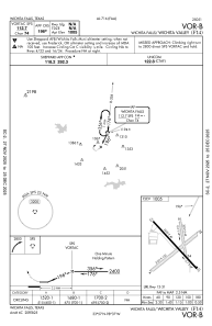
IAC chart of F14
 Satellite view of F14
Satellite view of F14
Sorry, we have no imagery here.
Sorry, we have no imagery here.
Sorry, we have no imagery here.
Sorry, we have no imagery here.
Sorry, we have no imagery here.
Sorry, we have no imagery here.


F14 - Wichita Valley
Located in Wichita Falls, United States
ICAO - F14, IATA -
Data provided by AirmateGeneral information
Coordinates: N33°56'51" W98°36'58"
Elevation is 1005 feet MSL.
Magnetic variation is 10° East View others Airports in Texas
Operational data
Special qualification required
Current time UTC:
Current local time:
Weather at : KSPS - Sheppard Afb/Wichita Falls Muni ( 12 km )
METAR: KSPS 021252Z 31004KT 10SM SCT070 BKN110 15/09 A2955 RMK AO2 SLP997 T01500094
TAF: KSPS 021213Z 0212/0312 30010KT P6SM BKN250 FM021600 27015G23KT P6SM SCT250 FM022200 27010KT P6SM BKN250 FM030100 08006KT P6SM FEW250 FM030600 04008KT P6SM -RA BKN070
Communications frequencies: [VIEW]
Runways:
| RWY identifier | QFU | Length (ft) | Width (ft) | Surface | LDA (ft) |
| 04 | 49° | 3107 | 100 | GRASS | |
| 22 | 229° | 3107 | 100 | GRASS | |
| 13 | 141° | 3320 | 40 | ASPH | |
| 31 | 321° | 3320 | 40 | ASPH | |
| 16 | 173° | 2037 | 42 | GRASS | |
| 34 | 353° | 2037 | 42 | GRASS |
Airport contact information
Address: Wichita Falls United States
Satellite view of F14
Sorry, we have no imagery here.
Sorry, we have no imagery here.
Sorry, we have no imagery here.
Sorry, we have no imagery here.
Sorry, we have no imagery here.
Sorry, we have no imagery here.