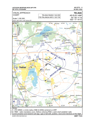
VAC chart of EYTL
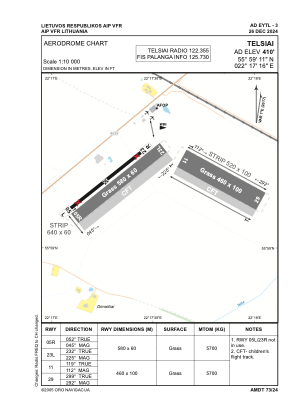
 ADC chart of EYTL
 Satellite view of EYTL
ADC chart of EYTL
Satellite view of EYTL
Sorry, we have no imagery here.
Sorry, we have no imagery here.
Sorry, we have no imagery here.
Sorry, we have no imagery here.
Sorry, we have no imagery here.
Sorry, we have no imagery here.


EYTL - Telsiai
Located in Telsiai, Lithuania
ICAO - EYTL, IATA -
Data provided by AirmateGeneral information
Coordinates: N55°59'11" E22°17'16"
Elevation is 410 feet MSL.
Magnetic variation is 7° East View others Airports in Telšiai County
Operational data
Special qualification required
Current time UTC:
Current local time:
Weather at : EYSA - Siauliai/Military/International ( 70 km )
METAR: EYSA 101150Z 31015KT 280V340 9999 BKN050 03/M09 Q1013 NOSIG
TAF: TAF EYSA 101109Z 1012/1021 35015KT 9000 BKN040 TEMPO 1012/1015 35018G28KT BKN035CB BECMG 1016/1018 VRB05KT
Communications frequencies: [VIEW]
Runways:
| RWY identifier | QFU | Length (ft) | Width (ft) | Surface | LDA (ft) |
| 05R | 52° | 1903 | 197 | GRASS | |
| 23L | 232° | 1903 | 197 | GRASS | |
| 11 | 119° | 1509 | 328 | GRASS | |
| 29 | 299° | 1509 | 328 | GRASS |
Airport contact information
Address: Telsiai Lithuania
Satellite view of EYTL
Sorry, we have no imagery here.
Sorry, we have no imagery here.
Sorry, we have no imagery here.
Sorry, we have no imagery here.
Sorry, we have no imagery here.
Sorry, we have no imagery here.