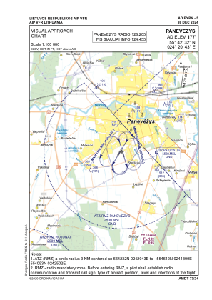
VAC chart of EYPN
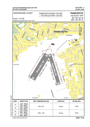
 ADC chart of EYPN
 Satellite view of EYPN
ADC chart of EYPN
Satellite view of EYPN
Sorry, we have no imagery here.
Sorry, we have no imagery here.
Sorry, we have no imagery here.
Sorry, we have no imagery here.
Sorry, we have no imagery here.
Sorry, we have no imagery here.


EYPN - Panevezys
Located in Panevezys, Lithuania
ICAO - EYPN, IATA - PNV
Data provided by AirmateGeneral information
Coordinates: N55°42'32" E24°20'43"
Elevation is 177 feet MSL.
Magnetic variation is 7° East View others Airports in Panevežys County
Operational data
Special qualification required
Current time UTC:
Current local time:
Weather at : EYSA - Siauliai/Military/International ( 63 km )
METAR: EYSA 111020Z 29013KT 270V330 9999 BKN017 BKN062 08/03 Q1002 NOSIG
TAF: TAF EYSA 110812Z 1109/1118 25010KT 9000 BKN010 BECMG 1109/1110 31013KT BKN025 TEMPO 1112/1115 33015G25KT
Communications frequencies: [VIEW]
Runways:
| RWY identifier | QFU | Length (ft) | Width (ft) | Surface | LDA (ft) |
| 02 | 31° | 1608 | 328 | GRASS | |
| 20 | 211° | 1608 | 328 | GRASS | |
| 16 | 163° | 1772 | 197 | GRASS | |
| 34 | 343° | 1772 | 197 | GRASS |
Airport contact information
Address: Panevezys Lithuania
Other aviation service providers
Aviation club (not for profit)

Satellite view of EYPN
Sorry, we have no imagery here.
Sorry, we have no imagery here.
Sorry, we have no imagery here.
Sorry, we have no imagery here.
Sorry, we have no imagery here.
Sorry, we have no imagery here.