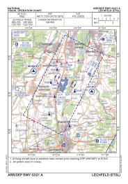
VAC chart of ETSL
 IAC chart of ETSL
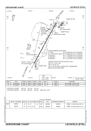
 ADC chart of ETSL
 Satellite view of ETSL
IAC chart of ETSLADC chart of ETSL
Satellite view of ETSL
Sorry, we have no imagery here.
Sorry, we have no imagery here.
Sorry, we have no imagery here.
Sorry, we have no imagery here.
Sorry, we have no imagery here.
Sorry, we have no imagery here.


ETSL - Lechfeld
Located in Lagerlechfeld, Germany
ICAO - ETSL, IATA -
Data provided by AirmateGeneral information
Coordinates: N48°11'8" E10°51'40"
Elevation is 1822 feet MSL.
Magnetic variation is 4.14° East View others Airports in Bavaria
Operational data
Special qualification required
Current time UTC:
Current local time:
Weather
METAR: ETSL 070520Z 02004KT 9999 FEW230 M03/M07 Q1021 BLU+
Communications frequencies: [VIEW]
Runways:
| RWY identifier | QFU | Length (ft) | Width (ft) | Surface | LDA (ft) |
| 03 | 29° | 8787 | 98 | ASPH | 8787 |
| 21 | 209° | 8787 | 98 | ASPH | 8787 |
Airport contact information
Address: Lagerlechfeld Germany
Other aviation service providers
Aviation club (not for profit)

Bundeswehr-Sportflieger-Gemeinschaft Fürstenfeldbruck E.V.
Bundeswehr-Sportflieger-Gemeinschaft Fürstenfeldbruck E.V.
info@fursty.de+49814191342
Satellite view of ETSL
Sorry, we have no imagery here.
Sorry, we have no imagery here.
Sorry, we have no imagery here.
Sorry, we have no imagery here.
Sorry, we have no imagery here.
Sorry, we have no imagery here.