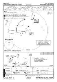
IAC chart of ETNT
 ADC chart of ETNT
 Satellite view of ETNT
ADC chart of ETNT
Satellite view of ETNT
Sorry, we have no imagery here.
Sorry, we have no imagery here.
Sorry, we have no imagery here.
Sorry, we have no imagery here.
Sorry, we have no imagery here.


ETNT - Wittmundhafen
Located in Wittmund, Germany
ICAO - ETNT, IATA -
Data provided by AirmateGeneral information
Coordinates: N53°32'52" E7°40'3"
Elevation is 26 feet MSL.
Magnetic variation is 3.46° East View others Airports in Lower Saxony
Operational data
Special qualification required
Current time UTC:
Current local time:
Weather
METAR: ETNT 111920Z AUTO 32004KT //// // ////// 09/07 Q1018 ///
Communications frequencies: [VIEW]
Runways:
| RWY identifier | QFU | Length (ft) | Width (ft) | Surface | LDA (ft) |
| 08 | 78° | 8005 | 98 | CONC+ASPH | 8005 |
| 26 | 258° | 8005 | 98 | CONC+ASPH | 8005 |
Airport contact information
Address: Wittmund Germany
Other aviation service providers
Aviation club (not for profit)

Fluggruppe Jg 71 'Richthofen' E. V.
Fluggruppe Jg 71 'Richthofen' E. V.
1.vorsitzender@fluggruppe.de+4944661458
Satellite view of ETNT
Sorry, we have no imagery here.
Sorry, we have no imagery here.
Sorry, we have no imagery here.
Sorry, we have no imagery here.
Sorry, we have no imagery here.