VAC chart of ETNS
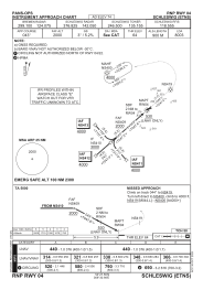
 IAC chart of ETNS
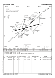
 ADC chart of ETNS
 Satellite view of ETNS
IAC chart of ETNSADC chart of ETNS
Satellite view of ETNS
Sorry, we have no imagery here.
Sorry, we have no imagery here.
Sorry, we have no imagery here.
Sorry, we have no imagery here.
Sorry, we have no imagery here.
Sorry, we have no imagery here.


ETNS - Schleswig
Located in Schleswig, Germany
ICAO - ETNS, IATA - WBG
Data provided by AirmateGeneral information
Coordinates: N54°27'34" E9°30'59"
Elevation is 74 feet MSL.
Magnetic variation is 4.07° East View others Airports in Schleswig-Holstein
Operational data
Special qualification required
Current time UTC:
Current local time:
Weather
METAR: ETNS 112020Z AUTO 30012KT //// // ////// 09/07 Q1016 ///
Communications frequencies: [VIEW]
Runways:
| RWY identifier | QFU | Length (ft) | Width (ft) | Surface | LDA (ft) |
| 07 | 74° | 8071 | 144 | CONC+ASPH | 8071 |
| 25 | 254° | 8071 | 144 | CONC+ASPH | 8071 |
| 05 | 48° | 8003 | 98 | CONC+ASPH | 8003 |
| 23 | 228° | 8003 | 98 | CONC+ASPH | 8003 |
Airport contact information
Address: Schleswig Germany
Satellite view of ETNS
Sorry, we have no imagery here.
Sorry, we have no imagery here.
Sorry, we have no imagery here.
Sorry, we have no imagery here.
Sorry, we have no imagery here.
Sorry, we have no imagery here.