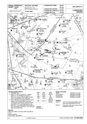
VAC chart of ESTL
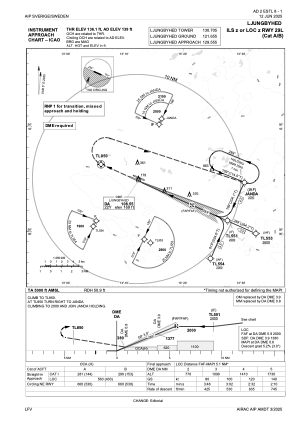
 IAC chart of ESTL
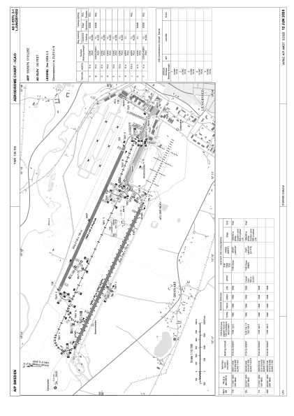
 ADC chart of ESTL
 Satellite view of ESTL
IAC chart of ESTLADC chart of ESTL
Satellite view of ESTL
Sorry, we have no imagery here.
Sorry, we have no imagery here.
Sorry, we have no imagery here.
Sorry, we have no imagery here.
Sorry, we have no imagery here.
Sorry, we have no imagery here.


ESTL - Ljungbyhed
Located in Ljungbyhed, Sweden
ICAO - ESTL, IATA -
Data provided by AirmateGeneral information
Coordinates: N56°5'7" E13°12'25"
Elevation is 139 feet MSL.
Magnetic variation is +4.0° East View others Airports in Skåne län
Operational data
Special qualification required
Current time UTC:
Current local time:
Weather at : ESMS - Malmoe ( 60 km )
METAR: ESMS 060650Z 34004KT CAVOK 01/M04 Q1028
TAF: TAF ESMS 060501Z 0606/0706 VRB02KT 9999 FEW045 BECMG 0610/0613 31010KT
Communications frequencies: [VIEW]
Runways:
| RWY identifier | QFU | Length (ft) | Width (ft) | Surface | LDA (ft) |
| 11L | 113° | 6555 | 131 | ASP | |
| 29R | 293° | 6555 | 131 | ASP | |
| 11R | 113° | 6516 | 131 | ASP | |
| 29L | 293° | 6516 | 131 | ASP |
Airport contact information
Address: Ljungbyhed Sweden
Other aviation service providers
Aviation club (not for profit)

Lunds Universitet Trafikflyghögskolan
Lunds Universitet Trafikflyghögskolan
thomas.hallstrom@tfhs.lu.se+46435445400
Satellite view of ESTL
Sorry, we have no imagery here.
Sorry, we have no imagery here.
Sorry, we have no imagery here.
Sorry, we have no imagery here.
Sorry, we have no imagery here.
Sorry, we have no imagery here.