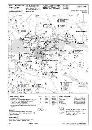
VAC chart of ESSP
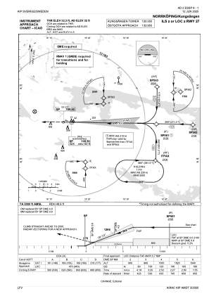
 IAC chart of ESSP
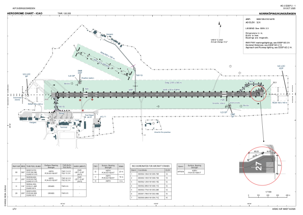
 ADC chart of ESSP
 Satellite view of ESSP

IAC chart of ESSPADC chart of ESSP
Satellite view of ESSP
Sorry, we have no imagery here.
Sorry, we have no imagery here.
Sorry, we have no imagery here.
Sorry, we have no imagery here.
Sorry, we have no imagery here.
Sorry, we have no imagery here.


ESSP - Norrkoeping/Kungsaengen
Located in Norrkoeping, Sweden
ICAO - ESSP, IATA - NRK
Data provided by AirmateGeneral information
Coordinates: N58°35'10" E16°14'47"
Elevation is 32 feet MSL.
Magnetic variation is +6.0° East View others Airports in Östergötlands län
Operational data
Special qualification required
Current time UTC:
Current local time:
Weather at : - ( 0 km )
METAR: KJXI 092235Z AUTO 18013G18KT 10SM CLR 25/06 A3005 RMK AO2 T02500063
Communications frequencies: [VIEW]
Runways:
| RWY identifier | QFU | Length (ft) | Width (ft) | Surface | LDA (ft) |
| 09 | 91° | 7234 | 148 | ASP | |
| 27 | 271° | 7234 | 148 | ASP | |
| 11 | 115° | 1969 | 115 | GRS | |
| 29 | 295° | 1969 | 115 | GRS |
Airport contact information
Address: Norrkoeping Sweden
Other aviation service providers
Flight schools

Aviation club (not for profit)

Satellite view of ESSP
Sorry, we have no imagery here.
Sorry, we have no imagery here.
Sorry, we have no imagery here.
Sorry, we have no imagery here.
Sorry, we have no imagery here.
Sorry, we have no imagery here.