VAC chart of ESDF
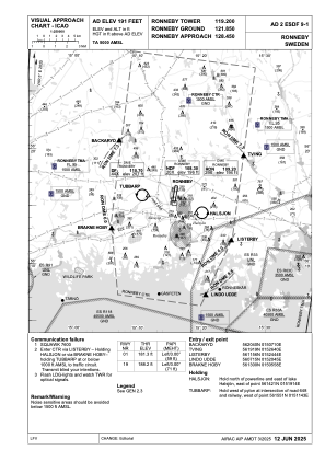 IAC chart of ESDF
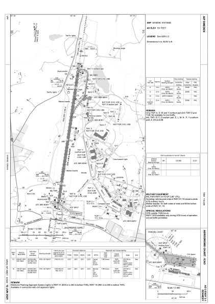
 ADC chart of ESDF
 Satellite view of ESDF
IAC chart of ESDFADC chart of ESDF
Satellite view of ESDF
Sorry, we have no imagery here.
Sorry, we have no imagery here.
Sorry, we have no imagery here.
Sorry, we have no imagery here.
Sorry, we have no imagery here.
Sorry, we have no imagery here.


ESDF - Ronneby
Located in Ronneby, Sweden
ICAO - ESDF, IATA - RNB
Data provided by AirmateGeneral information
Coordinates: N56°16'0" E15°15'54"
Elevation is 191 feet MSL.
Magnetic variation is +5.0° East View others Airports in Blekinge län
Operational data
Special qualification required
Current time UTC:
Current local time:
Weather at : - ( 0 km )
METAR: PPIT 060756Z AUTO 33017KT 10SM CLR M09/M10 A2978 RMK AO2 SLP089 T10891100 FZRANO
Communications frequencies: [VIEW]
Runways:
| RWY identifier | QFU | Length (ft) | Width (ft) | Surface | LDA (ft) |
| 12 | 0° | 1969 | 98 | UNK | |
| 30 | 0° | 1969 | 98 | UNK | |
| 01 | 9° | 7648 | 148 | ASP | |
| 19 | 189° | 7648 | 148 | ASP |
Airport contact information
Address: Ronneby Sweden
Other aviation service providers
Aviation club (not for profit)

Satellite view of ESDF
Sorry, we have no imagery here.
Sorry, we have no imagery here.
Sorry, we have no imagery here.
Sorry, we have no imagery here.
Sorry, we have no imagery here.
Sorry, we have no imagery here.