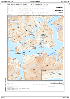
VAC chart of ENSG
 IAC chart of ENSG
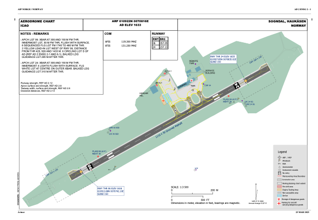
 ADC chart of ENSG
 Satellite view of ENSG
IAC chart of ENSGADC chart of ENSG
Satellite view of ENSG
Sorry, we have no imagery here.
Sorry, we have no imagery here.
Sorry, we have no imagery here.
Sorry, we have no imagery here.
Sorry, we have no imagery here.
Sorry, we have no imagery here.


ENSG - Haukaasen
Located in Sogndal, Norway
ICAO - ENSG, IATA - SOG
Data provided by AirmateGeneral information
Coordinates: N61°9'22" E7°8'16"
Elevation is 1633 feet MSL.
Magnetic variation is 2.2° East View others Airports in Sogn og Fjordane
Operational data
Special qualification required
Current time UTC:
Current local time:
Weather
METAR: ENSG 091720Z VRB02KT 9999 FEW/// BKN040 02/01 Q1007 RMK WIND 3806FT 24012KT
TAF: TAF ENSG 091400Z 0915/0922 VRB04KT 9999 FEW000 BKN045
Communications frequencies: [VIEW]
Runways:
| RWY identifier | QFU | Length (ft) | Width (ft) | Surface | LDA (ft) |
| 06 | 0° | 3642 | 98 | UNK | |
| 24 | 0° | 3642 | 98 | UNK |
Airport contact information
Address: Sogndal Norway
Satellite view of ENSG
Sorry, we have no imagery here.
Sorry, we have no imagery here.
Sorry, we have no imagery here.
Sorry, we have no imagery here.
Sorry, we have no imagery here.
Sorry, we have no imagery here.